
Winchester topographic map
Interactive map
Click on the map to display elevation.
About this map
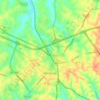
Name: Winchester topographic map, elevation, terrain.
Location: Winchester, Clark County, Kentucky, United States (37.97144 -84.22872 38.04113 -84.15570)
Average elevation: 296 m
Minimum elevation: 269 m
Maximum elevation: 328 m
Other topographic maps
Click on a map to view its topography, its elevation and its terrain.
Ford
United States > Kentucky > Clark County
Ford, Clark County, Kentucky, United States
Average elevation: 235 m
Wesleyan Park
United States > Kentucky > Clark County > Winchester
Wesleyan Park, Winchester, Clark County, Kentucky, 40391, United States
Average elevation: 297 m
Ruckerville
United States > Kentucky > Clark County > Ruckerville
Ruckerville, Clark County, Kentucky, United States
Average elevation: 282 m