
Make a donation
Gear up for your next adventure:
As an Amazon Associate, this site earns from qualifying purchases at no extra cost to you.
Ernatsreute topographic map
Click on the map to display elevation.
Make a donation
Gear up for your next adventure:
As an Amazon Associate, this site earns from qualifying purchases at no extra cost to you.
About this map
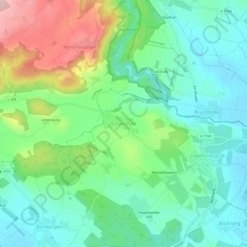
Name: Ernatsreute topographic map, elevation, terrain.
Average elevation: 535 m
Minimum elevation: 461 m
Maximum elevation: 701 m
Make a donation
Gear up for your next adventure:
As an Amazon Associate, this site earns from qualifying purchases at no extra cost to you.
Other topographic maps
Click on a map to view its topography, its elevation and its terrain.
Überlinger See
Deutschland > Baden-Württemberg > Bodenseekreis > Überlingen
Von der Gesamtfläche des Obersees von insgesamt 473 km² nimmt der Überlinger See 61 km² ein und ist damit etwa so groß wie der Untersee. Die Meereshöhe der Wasseroberfläche liegt bei rund 395 m ü. NN. Die Wassertiefe des Überlinger Sees ist mit maximal 147 m deutlich geringer als die des Obersees mit 251 m.
Average elevation: 452 m