
Rottbitze topographic map
Interactive map
Click on the map to display elevation.
About this map
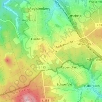
Name: Rottbitze topographic map, elevation, terrain.
Average elevation: 294 m
Minimum elevation: 209 m
Maximum elevation: 411 m
Other topographic maps
Click on a map to view its topography, its elevation and its terrain.
Orscheid
Deutschland > Nordrhein-Westfalen > Rhein-Sieg-Kreis > Bad Honnef
Orscheid, Bad Honnef, Rhein-Sieg-Kreis, Nordrhein-Westfalen, 53578, Deutschland
Average elevation: 274 m
Wülscheid
Deutschland > Nordrhein-Westfalen > Rhein-Sieg-Kreis > Bad Honnef > Wülscheid
Wülscheid, Bad Honnef, Rhein-Sieg-Kreis, Nordrhein-Westfalen, 53578, Deutschland
Average elevation: 267 m
Hövel
Deutschland > Nordrhein-Westfalen > Rhein-Sieg-Kreis > Bad Honnef
Hövel, Bad Honnef, Rhein-Sieg-Kreis, Nordrhein-Westfalen, 53604, Deutschland
Average elevation: 242 m