
Boston topographic map
Click on the map to display elevation.
Boston
Boston has an area of 89.63 sq mi (232.1 km2)—48.4 sq mi (125.4 km2) (54%) of land and41.2 sq mi (106.7 km2) (46%) of water. The city's official elevation, as measured at Logan International Airport, is 19 ft (5.8 m) above sea level. The highest point in Boston is Bellevue Hill at 330 ft (100 m) above sea level, and the lowest point is at sea level. Boston is situated on Boston Harbor, an arm of Massachusetts Bay, itself an arm of the Atlantic Ocean.
About this map
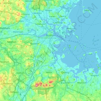
Name: Boston topographic map, elevation, terrain.
Location: Boston, Suffolk County, Massachusetts, United States (42.22791 -71.19124 42.39698 -70.80449)
Average elevation: 25 m
Minimum elevation: -5 m
Maximum elevation: 184 m
Other topographic maps
Click on a map to view its topography, its elevation and its terrain.
Boston
United States > Massachusetts > Suffolk County > Boston
Boston has an area of 89.63 sq mi (232.1 km2)—48.4 sq mi (125.4 km2) (54%) of land and41.2 sq mi (106.7 km2) (46%) of water. The city's official elevation, as measured at Logan International Airport, is 19 ft (5.8 m) above sea level. The highest point in Boston is Bellevue Hill at 330 ft (100 m) above sea…
Average elevation: 26 m
Kevin W. Fitzgerald Park
United States > Massachusetts > Suffolk County > Boston
Average elevation: 17 m