
Nocera Umbra topographic map
Interactive map
Click on the map to display elevation.
About this map
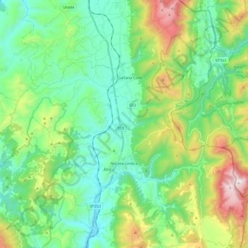
Name: Nocera Umbra topographic map, elevation, terrain.
Location: Nocera Umbra, Perugia, Umbria, 06025, Italy (43.05950 12.68893 43.21754 12.89733)
Average elevation: 695 m
Minimum elevation: 361 m
Maximum elevation: 1,567 m
Other topographic maps
Click on a map to view its topography, its elevation and its terrain.
Strada provinciale di Bagnara
Italy > Umbria > Perugia > Nocera Umbra > Collecroce
Strada provinciale di Bagnara, Collecroce, Nocera Umbra, Perugia, Umbria, 06025, Italy
Average elevation: 1,244 m