
Thank you for supporting this site ❤️
Make a donation
Make a donation
Gear up for your next adventure:
As an Amazon Associate, this site earns from qualifying purchases at no extra cost to you.
Banyoles topographic map
Click on the map to display elevation.
Thank you for supporting this site ❤️
Make a donation
Make a donation
Gear up for your next adventure:
As an Amazon Associate, this site earns from qualifying purchases at no extra cost to you.
About this map
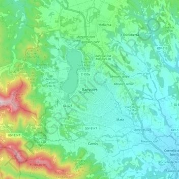
Name: Banyoles topographic map, elevation, terrain.
Location: Banyoles, Pla de l'Estany, Girona, Catalonia, 17820, Spain (42.07805 2.72536 42.15805 2.80536)
Average elevation: 217 m
Minimum elevation: 92 m
Maximum elevation: 622 m
Thank you for supporting this site ❤️
Make a donation
Make a donation
Gear up for your next adventure:
As an Amazon Associate, this site earns from qualifying purchases at no extra cost to you.