
Make a donation
Gear up for your next adventure:
As an Amazon Associate, this site earns from qualifying purchases at no extra cost to you.
Hong Kong topographic map
Click on the map to display elevation.
Gear up for your next adventure:
As an Amazon Associate, this site earns from qualifying purchases at no extra cost to you.
Hong Kong
Hong Kong has a humid subtropical climate (Köppen Cwa), characteristic of southern China, despite being located south of the Tropic of Cancer. Summer is hot and humid, with occasional showers and thunderstorms and warm air from the southwest. Typhoons occur most often then, sometimes resulting in floods or landslides. Winters are mild and usually sunny at the beginning, becoming cloudy towards February. Frequent cold fronts bring strong, cooling winds from the north and occasionally result in chilly weather. Autumn is the sunniest season, whilst spring is generally cloudy. When there is snowfall, which is extremely rare, it is usually at high elevations. Hong Kong averages 1,709 hours of sunshine per year. Historic temperature extremes at the Hong Kong Observatory are 36.6 °C (97.9 °F) on 22 August 2017 and 0.0 °C (32.0 °F) on 18 January 1893. The highest and lowest recorded temperatures in all of Hong Kong are 39.0 °C (102 °F) at Wetland Park on 22 August 2017, and −6.0 °C (21.2 °F) at Tai Mo Shan on 24 January 2016.
Make a donation
Gear up for your next adventure:
As an Amazon Associate, this site earns from qualifying purchases at no extra cost to you.
About this map
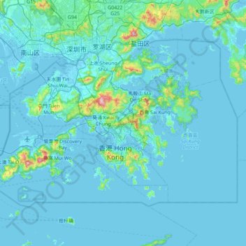
Name: Hong Kong topographic map, elevation, terrain.
Location: Hong Kong, China (22.13672 113.81724 22.56833 114.50249)
Average elevation: 47 m
Minimum elevation: -6 m
Maximum elevation: 938 m
Make a donation
Gear up for your next adventure:
As an Amazon Associate, this site earns from qualifying purchases at no extra cost to you.
Other topographic maps
Click on a map to view its topography, its elevation and its terrain.
Chongqing
The central urban area of Chongqing, or Chongqing proper, is a city of unique features. Built on mountains and partially surrounded by the Yangtze and Jialing rivers, it is known as a "mountain city" and a "city on rivers". The night scene of the city is very illuminated, with millions of lights and their…
Average elevation: 318 m
Make a donation
Gear up for your next adventure:
As an Amazon Associate, this site earns from qualifying purchases at no extra cost to you.
Make a donation
Gear up for your next adventure:
As an Amazon Associate, this site earns from qualifying purchases at no extra cost to you.
Make a donation
Gear up for your next adventure:
As an Amazon Associate, this site earns from qualifying purchases at no extra cost to you.
Make a donation
Gear up for your next adventure:
As an Amazon Associate, this site earns from qualifying purchases at no extra cost to you.
Make a donation
Gear up for your next adventure:
As an Amazon Associate, this site earns from qualifying purchases at no extra cost to you.
Mount Kailash
China > Tibet > Purang County > Darchen
Mount Kailash (also Kailasa, Gang Tise and Gang Rinpoche or Kangrinboqê) is a mountain in Ngari Prefecture, Tibet Autonomous Region of China. It lies in the Gangdise Shan mountain range of the Transhimalaya, in the western part of the Tibetan Plateau. The peak of Mount Kailash is located at an elevation of…
Average elevation: 5,756 m
Make a donation
Gear up for your next adventure:
As an Amazon Associate, this site earns from qualifying purchases at no extra cost to you.
Make a donation
Gear up for your next adventure:
As an Amazon Associate, this site earns from qualifying purchases at no extra cost to you.
Make a donation
Gear up for your next adventure:
As an Amazon Associate, this site earns from qualifying purchases at no extra cost to you.
Make a donation
Gear up for your next adventure:
As an Amazon Associate, this site earns from qualifying purchases at no extra cost to you.
Make a donation
Gear up for your next adventure:
As an Amazon Associate, this site earns from qualifying purchases at no extra cost to you.
Make a donation
Gear up for your next adventure:
As an Amazon Associate, this site earns from qualifying purchases at no extra cost to you.
Himalayas
The Himalayas, or Himalaya, is a mountain range in Asia separating the plains of the Indian subcontinent from the Tibetan Plateau. The range has some of the Earth's highest peaks, including the highest, Mount Everest. More than 100 peaks exceeding elevations of 7,200 m (23,600 ft) above sea level lie in the…
Average elevation: 2,385 m
Make a donation
Gear up for your next adventure:
As an Amazon Associate, this site earns from qualifying purchases at no extra cost to you.
Jade Dragon Snow Mountain
China > Yunnan > Lijiang City
The view of the massif from the gardens at the Black Dragon Pool (Heilong Tan) in Lijiang is noted as one of China's finest views. The mountain is part of Yulong Snow Mountain National Scenic Area and National Geological Park, an AAAAA-classified scenic area. The Park operates a tourist cable car that climbs…
Average elevation: 4,829 m
Shilin Stone Forest Landscape District
China > Yunnan > Shilin Yi Autonomous County > Kunming
The strata are part of a gentle (2-6 degree) westward dipping monocline. Conjugate shear joints (NE-SW and NE-SE) are well developed and these fractures provided the main passageways for surface and underground water in the pre-karst development stage. The distribution, density and orientation of the fractures…
Average elevation: 1,767 m
Make a donation
Gear up for your next adventure:
As an Amazon Associate, this site earns from qualifying purchases at no extra cost to you.
Make a donation
Gear up for your next adventure:
As an Amazon Associate, this site earns from qualifying purchases at no extra cost to you.
Make a donation
Gear up for your next adventure:
As an Amazon Associate, this site earns from qualifying purchases at no extra cost to you.
Make a donation
Gear up for your next adventure:
As an Amazon Associate, this site earns from qualifying purchases at no extra cost to you.
Make a donation
Gear up for your next adventure:
As an Amazon Associate, this site earns from qualifying purchases at no extra cost to you.
Tai Mo Shan
China > Hong Kong > Tsuen Wan District
Tai Mo Shan is the highest peak in Hong Kong, with an elevation of 957 metres (3,140 ft) above the Hong Kong Principal Datum [zh], or around 956 metres (3,136 ft) above mean sea level. It is located at approximately the geographical centre of the New Territories.
Average elevation: 600 m
Make a donation
Gear up for your next adventure:
As an Amazon Associate, this site earns from qualifying purchases at no extra cost to you.
Sunset Peak
Sunset Peak is only accessible by foot. It is located on section 2 of the 70 km (43 mi) long Lantau Trail. Section 2 is 6.5 km long and goes from Nam Shan Campsite west of Mui Wo on South Lantau Road (elevation about 120 m), to Pak Kung Au, another campsite on the Tung Chung Road (elevation about 340 m). Both…
Average elevation: 411 m
Broad Peak
China > Xinjiang > Taxkorgan Tajik Autonomous County > Dafdar
Broad Peak is one of the eight-thousanders, and is located in the Karakoram range spanning Gilgit-Baltistan, Pakistan and Xinjiang, China. It is the 12th highest mountain in the world at 8,051 metres (26,414 ft) elevation above sea level. The first ascent of this mountain was in June 1957, accomplished by…
Average elevation: 7,117 m
Himalayas
The Himalayas, or Himalaya (/ˌhɪməˈleɪ.ə, hɪˈmɑːləjə/ HIM-ə-LAY-ə, hih-MAH-lə-yə), is a mountain range in Asia, separating the plains of the Indian subcontinent from the Tibetan Plateau. The range has some of the Earth's highest peaks, including the highest, Mount Everest. More than 100 peaks…
Average elevation: 2,385 m
Make a donation
Gear up for your next adventure:
As an Amazon Associate, this site earns from qualifying purchases at no extra cost to you.
Himalayas
The Himalayas, or Himalaya (/ˌhɪməˈleɪ.ə, hɪˈmɑːləjə/ HIM-ə-LAY-ə, hih-MAH-lə-yə), is a mountain range in Asia, separating the plains of the Indian subcontinent from the Tibetan Plateau. The range has some of the Earth's highest peaks, including the highest, Mount Everest. More than 100 peaks…
Average elevation: 2,385 m
Wu Kai Sha Beach
China > Hong Kong > Sha Tin District > Wu Kai Sha Village > Cheung Kang Village
Average elevation: 36 m
Make a donation
Gear up for your next adventure:
As an Amazon Associate, this site earns from qualifying purchases at no extra cost to you.