
Thank you for supporting this site ❤️
Make a donation
Make a donation
Gear up for your next adventure:
As an Amazon Associate, this site earns from qualifying purchases at no extra cost to you.
Fuzi topographic map
Click on the map to display elevation.
Thank you for supporting this site ❤️
Make a donation
Make a donation
Gear up for your next adventure:
As an Amazon Associate, this site earns from qualifying purchases at no extra cost to you.
About this map
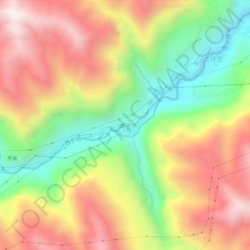
Name: Fuzi topographic map, elevation, terrain.
Location: Fuzi, Leibo County, Liangshan, Sichuan, 616500, China (28.51680 103.63766 28.55680 103.67766)
Average elevation: 1,164 m
Minimum elevation: 646 m
Maximum elevation: 1,675 m
Thank you for supporting this site ❤️
Make a donation
Make a donation
Gear up for your next adventure:
As an Amazon Associate, this site earns from qualifying purchases at no extra cost to you.