Geolocate

Uzh topographic map

Click on the map to display elevation.

About this map
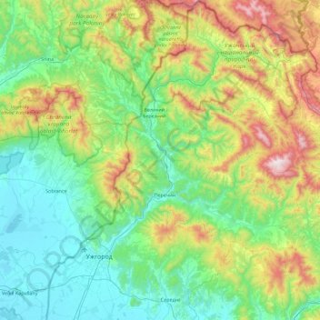
Name: Uzh topographic map, elevation, terrain.

Location: Uzh, Zakarpattia Oblast, Ukraine (48.59837 21.99018 49.00314 22.89472)

Average elevation: 441 m

Minimum elevation: 97 m

Maximum elevation: 1,476 m

Other topographic maps

Click on a map to view its topography, its elevation and its terrain.
Brebeneskul

Ukraine > Zakarpattia Oblast

Average elevation: 1,759 m

Vovchyi

Ukraine > Zakarpattia Oblast

Average elevation: 490 m

У Рея

Ukraine > Zakarpattia Oblast > Chertizh

Average elevation: 291 m

Zbyny

Ukraine > Zakarpattia Oblast

Average elevation: 559 m

Bukivtsovo

Ukraine > Zakarpattia Oblast

Average elevation: 566 m

Velyka

Ukraine > Zakarpattia Oblast

Average elevation: 154 m

Verkhnii Studenyi

Ukraine > Zakarpattia Oblast

Average elevation: 796 m

Gear up for your next adventure:

🔦Outdoor Torches - Reliable torches for night navigation
☕Insulated Travel Mugs - Keep drinks hot while surveying the landscape from a summit
📷Outdoor Action Cameras - Cameras designed for hiking and adventure
🧰First Aid Kits - Essential safety kits for outdoor activities
🧷Tenacious Repair Tape - Instant fix for torn tents, jackets, or dry bags

As an Amazon Associate, this site earns from qualifying purchases at no extra cost to you.