
Bérchules topographic map
Interactive map
Click on the map to display elevation.
Bérchules
Bérchules is a village and municipality in the central Alpujarra, in the province of Granada in Spain. The origins of the village are Arab. There are two villages in the municipality, Bérchules (36° 58' north and 3° 11' east, elevation 1350 metres), and Alcútar (36° 58' north and 3° 11' east, elevation 1250 metres). The villages are on the road, Órgiva-Trevélez-Ugíjar, and their population is estimated at 900 and 300 respectively.
About this map
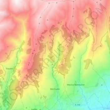
Name: Bérchules topographic map, elevation, terrain.
Average elevation: 1,885 m
Minimum elevation: 661 m
Maximum elevation: 3,080 m
Other topographic maps
Click on a map to view its topography, its elevation and its terrain.
Sierra Nevada
Spain > Andalusia > Comarca de la Alpujarra Granadina > Lanjarón
Average elevation: 2,223 m
Pico de Mulhacén
Spain > Andalusia > Comarca de la Alpujarra Granadina > Trevélez
Mulhacén ([mulaˈθen]), with an elevation of 3,482 metres (11,424 ft), is the highest mountain in peninsular Spain and in all of the Iberian Peninsula. It is part of the Sierra Nevada range in the Penibaetic System. It is named after Abu'l-Hasan Ali, known as Muley Hacén in Spanish, the penultimate Muslim…
Average elevation: 3,070 m
Pico del Veleta
Spain > Andalusia > Comarca de la Alpujarra Granadina > Capileira
The IRAM 30m telescope is located on the slopes of Pico Veleta, at an elevation of 2920 m.
Average elevation: 2,998 m