
Banff National Park topographic map
Interactive map
Click on the map to display elevation.
Banff National Park
Banff National Park has a subarctic climate with three ecoregions, including montane, subalpine, and alpine. The forests are dominated by Lodgepole pine at lower elevations and Engelmann spruce in higher ones below the treeline, above which is primarily rocks and ice. Mammal species such as the grizzly bear, cougar, wolverine, elk, bighorn sheep and moose are found, along with hundreds of bird species. Reptiles and amphibians are also found but only a limited number of species have been recorded.
About this map
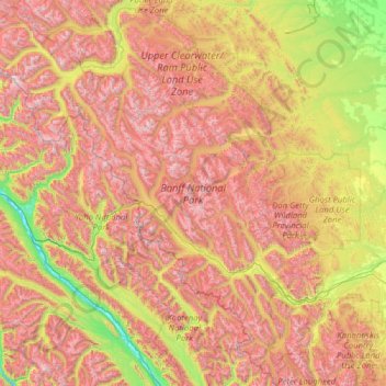
Name: Banff National Park topographic map, elevation, terrain.
Location: Banff National Park, Division No. 15, Alberta, Canada (50.70506 -117.31712 52.27145 -115.16491)
Average elevation: 1,848 m
Minimum elevation: 773 m
Maximum elevation: 3,472 m
Other topographic maps
Click on a map to view its topography, its elevation and its terrain.
Moraine Lake
Canada > Alberta > Division No. 15
Moraine Lake is a glacially fed lake in Banff National Park, 14 kilometres (8.7 mi) outside the hamlet of Lake Louise, Alberta, Canada. It is situated in the Valley of the Ten Peaks, at an elevation of approximately 1,884 metres (6,181 ft). The lake has a surface area of 50 hectares (120 acres).
Average elevation: 2,101 m