
Mawsley topographic map
Click on the map to display elevation.
About this map
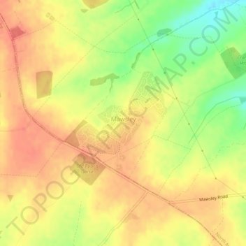
Name: Mawsley topographic map, elevation, terrain.
Location: Mawsley, North Northamptonshire, England, United Kingdom (52.36898 -0.82458 52.38109 -0.80469)
Average elevation: 132 m
Minimum elevation: 98 m
Maximum elevation: 150 m
North Northamptonshire trails, hiking, mountain biking, running and outdoor activities
Other topographic maps
Click on a map to view its topography, its elevation and its terrain.
Irchester Country Park
United Kingdom > England > North Northamptonshire > Little Irchester
Average elevation: 60 m
River Nene Navigation
United Kingdom > England > North Northamptonshire > Irchester
Average elevation: 55 m