
Make a donation
Gear up for your next adventure:
As an Amazon Associate, this site earns from qualifying purchases at no extra cost to you.
Luochuan County topographic map
Click on the map to display elevation.
Make a donation
Gear up for your next adventure:
As an Amazon Associate, this site earns from qualifying purchases at no extra cost to you.
Luochuan County
The area is largely hilly, with an average elevation of 1,072 metres (3,517 ft) in height. The Luo River flows through the county from its north to its southeast. The county is approximately 95 kilometres (59 mi) to the south of Yan'an's urban core, and approximately 200 kilometres (120 mi) to the north of Xi'an's urban core.
Make a donation
Gear up for your next adventure:
As an Amazon Associate, this site earns from qualifying purchases at no extra cost to you.
About this map
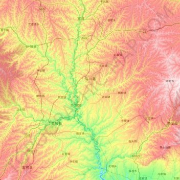
Name: Luochuan County topographic map, elevation, terrain.
Location: Luochuan County, Yan'an, Shaanxi, China (35.35145 109.30845 36.07702 109.76746)
Average elevation: 1,135 m
Minimum elevation: 648 m
Maximum elevation: 1,706 m
Make a donation
Gear up for your next adventure:
As an Amazon Associate, this site earns from qualifying purchases at no extra cost to you.