
Eldoret topographic map
Click on the map to display elevation.
Eldoret
Eldoret is a principal town in the Rift Valley region of Kenya and serves as the capital of Uasin Gishu County. The town is colloquially known as 'Chebarbar', a parody name from the Chebarbar River that lies about 7 kilometers from Kapsabet town, on the main highway to the town of Eldoret. As per the 2019 Kenya Population and Housing Census, Eldoret is the sixth most populated urban area in the country after Nairobi, Mombasa, Kisumu, Nakuru and Ruiru. Lying south of the Cherangani Hills, the local elevation varies from about 2100 metres at the airport to more than 2700 metres in nearby areas (7000–9000 feet). The population was 289,380 in the 2009 census, and it is currently the fastest growing town in Kenya with 475,716 inhabitants according to 2019 national census.
About this map
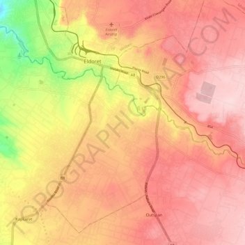
Name: Eldoret topographic map, elevation, terrain.
Location: Eldoret, Uasin Gishu, Kenya (0.43530 35.22292 0.54779 35.32606)
Average elevation: 2,111 m
Minimum elevation: 1,968 m
Maximum elevation: 2,204 m