
Municipio Baruta topographic map
Interactive map
Click on the map to display elevation.
About this map
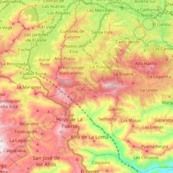
Name: Municipio Baruta topographic map, elevation, terrain.
Location: Municipio Baruta, Miranda, Región Capital, Venezuela (10.34050 -66.90054 10.49076 -66.75222)
Average elevation: 1,047 m
Minimum elevation: 484 m
Maximum elevation: 1,542 m
Other topographic maps
Click on a map to view its topography, its elevation and its terrain.
Los Teques
Venezuela > Miranda > Los Teques
Los Teques, Municipio Guaicaipuro, Miranda, Región Capital, 1201, Venezuela
Average elevation: 1,076 m
Urbanizacion Prados del Este
Venezuela > Miranda > Urbanizacion Prados del Este
Urbanizacion Prados del Este, Municipio Baruta, Miranda, Región Capital, 1080, Venezuela
Average elevation: 1,009 m