
Shire of Moyne topographic map
Interactive map
Click on the map to display elevation.
About this map
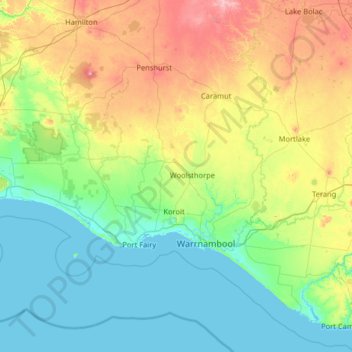
Name: Shire of Moyne topographic map, elevation, terrain.
Location: Shire of Moyne, Victoria, Australia (-38.61014 141.81707 -37.76555 143.10732)
Average elevation: 96 m
Minimum elevation: -1 m
Maximum elevation: 418 m
Other topographic maps
Click on a map to view its topography, its elevation and its terrain.
Dandenong Ranges
Australia > Victoria > Melbourne
The topography consists of a series of ridges dissected by deeply cut streams. Sheltered gullies in the south of the range are home to temperate rain forest, fern gullies and Mountain Ash forest Eucalyptus regnans, whereas the drier ridges and exposed northern slopes are covered by dry sclerophyll forest of…
Average elevation: 456 m
Australian Garden - Royal Botanic Gardens Cranbourne
Australia > Victoria > Melbourne
Average elevation: 70 m
Narre Warren North Retarding Basin (Melbourne Water)
Australia > Victoria > Melbourne
Average elevation: 76 m