
Fos-sur-Mer topographic map
Interactive map
Click on the map to display elevation.
About this map
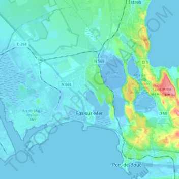
Name: Fos-sur-Mer topographic map, elevation, terrain.
Average elevation: 10 m
Minimum elevation: -16 m
Maximum elevation: 107 m
Other topographic maps
Click on a map to view its topography, its elevation and its terrain.
Mont Saint-Cyr
France > Provence-Alpes-Côte d'Azur > Bouches-du-Rhône > Marseille
Average elevation: 382 m
Bassin du Vallon Dol
France > Provence-Alpes-Côte d'Azur > Bouches-du-Rhône > Marseille
Average elevation: 241 m
Le Baguier
France > Provence-Alpes-Côte d'Azur > Bouches-du-Rhône > La Ciotat
Average elevation: 127 m
La Cride
France > Provence-Alpes-Côte d'Azur > Bouches-du-Rhône > Le Puy-Sainte-Réparade
Average elevation: 304 m
Aix-en-Provence
France > Provence-Alpes-Côte d'Azur > Bouches-du-Rhône > Aix-en-Provence
Average elevation: 279 m