
Make a donation
Gear up for your next adventure:
As an Amazon Associate, this site earns from qualifying purchases at no extra cost to you.
Brivezac topographic map
Click on the map to display elevation.
Make a donation
Gear up for your next adventure:
As an Amazon Associate, this site earns from qualifying purchases at no extra cost to you.
Brivezac
L'altitude minimale, 139 mètres, se trouve à l'extrême sud, près du lieu-dit Rieux, là où la Dordogne quitte la commune pour servir de limite entre celles d'Altillac et de Beaulieu-sur-Dordogne. L'altitude maximale avec 432 mètres est localisée au nord-ouest, dans le secteur du Puy la Rode.
Make a donation
Gear up for your next adventure:
As an Amazon Associate, this site earns from qualifying purchases at no extra cost to you.
About this map
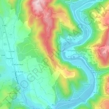
Name: Brivezac topographic map, elevation, terrain.
Average elevation: 247 m
Minimum elevation: 145 m
Maximum elevation: 453 m
Make a donation
Gear up for your next adventure:
As an Amazon Associate, this site earns from qualifying purchases at no extra cost to you.
Other topographic maps
Click on a map to view its topography, its elevation and its terrain.