
Make a donation
Gear up for your next adventure:
As an Amazon Associate, this site earns from qualifying purchases at no extra cost to you.
Riotinto topographic map
Click on the map to display elevation.
Make a donation
Gear up for your next adventure:
As an Amazon Associate, this site earns from qualifying purchases at no extra cost to you.
About this map
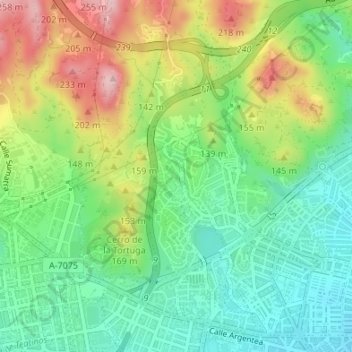
Name: Riotinto topographic map, elevation, terrain.
Average elevation: 102 m
Minimum elevation: 15 m
Maximum elevation: 244 m
Make a donation
Gear up for your next adventure:
As an Amazon Associate, this site earns from qualifying purchases at no extra cost to you.
Other topographic maps
Click on a map to view its topography, its elevation and its terrain.
Málaga
España > Andalucía > Málaga-Costa del Sol > Málaga
La ciudad está situada a una altitud de 8 m sobre el nivel del mar y se abre a una amplia bahía rodeada por las estribaciones meridionales de los Montes de Málaga, que desde el municipio del Rincón de la Victoria, recorren la ciudad paralelas a la costa en dirección este-oeste y que comprenden los…
Average elevation: 215 m
Make a donation
Gear up for your next adventure:
As an Amazon Associate, this site earns from qualifying purchases at no extra cost to you.
Make a donation
Gear up for your next adventure:
As an Amazon Associate, this site earns from qualifying purchases at no extra cost to you.
Make a donation
Gear up for your next adventure:
As an Amazon Associate, this site earns from qualifying purchases at no extra cost to you.