Geolocate

Springe topographic map

Click on the map to display elevation.

About this map

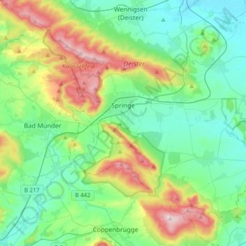
Name: Springe topographic map, elevation, terrain.

Location: Springe, Region Hannover, Lower Saxony, 31832, Germany (52.12836 9.46406 52.26541 9.75358)

Average elevation: 160 m

Minimum elevation: 65 m

Maximum elevation: 416 m

Other topographic maps

Click on a map to view its topography, its elevation and its terrain.

Altwarmbüchen

Germany > Lower Saxony > Region Hannover

Average elevation: 57 m

Kirchhorst

Germany > Lower Saxony > Region Hannover

Average elevation: 60 m

Dachtmissen

Germany > Lower Saxony > Region Hannover > Burgdorf

Average elevation: 53 m

Resse

Germany > Lower Saxony > Region Hannover

Average elevation: 48 m

Scherenbostel

Germany > Lower Saxony > Region Hannover

Average elevation: 60 m

Liethe

Germany > Lower Saxony > Region Hannover > Wunstorf

Average elevation: 46 m

Hanover

Germany > Lower Saxony > Region Hannover > Hanover

In 1636 George, Duke of Brunswick-Lüneburg, ruler of the Brunswick-Lüneburg principality of Calenberg, moved his residence to Hanover. The Dukes of Brunswick-Lüneburg were elevated by the Holy Roman Emperor to the rank of Prince-Elector in 1692 and this elevation was confirmed by the Imperial Diet in 1708.…

Average elevation: 70 m

Gear up for your next adventure:

🥾Hiking Boot Waterproofing Wax - Maintain the lifespan of your leather trekking boots
🧼Camping Hygiene Kits - Compact hygiene essentials for outdoor stays
🥤Hiking Water Bottles - Reusable bottles for hydration on the trail
🎒Multi-day Trekking Packs - Large capacity backpacks for wild camping and long-distance trails
🧺Ultralight Dry Bags - Organize and waterproof your gear inside your rucksack

As an Amazon Associate, this site earns from qualifying purchases at no extra cost to you.