Geolocate

Plön topographic map

Click on the map to display elevation.

About this map
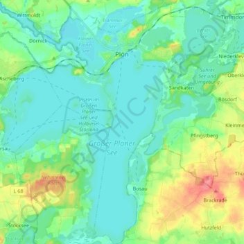
Name: Plön topographic map, elevation, terrain.

Location: Plön, Kreis Plön, Schleswig-Holstein, 24306, Germany (54.08196 10.33037 54.17965 10.49508)

Average elevation: 34 m

Minimum elevation: 15 m

Maximum elevation: 91 m

Other topographic maps

Click on a map to view its topography, its elevation and its terrain.
Heidkate

Germany > Schleswig-Holstein > Kreis Plön > Wisch

Average elevation: -1 m

Gear up for your next adventure:

🧴Tick Removal Tools - Small, essential health tool for UK woodland and moorland
🍱Food Containers - Reusable containers for outdoor meals
🔪Outdoor Multi-Tools - Versatile tools for gear repairs and food prep in the wild
📍Handheld GPS Navigators - Reliable satellite navigation for hiking and off-road exploration
🗺️Ordnance Survey Maps - Essential paper maps for hiking across the UK national parks

As an Amazon Associate, this site earns from qualifying purchases at no extra cost to you.