Geolocate

Dago topographic map

Click on the map to display elevation.

About this map

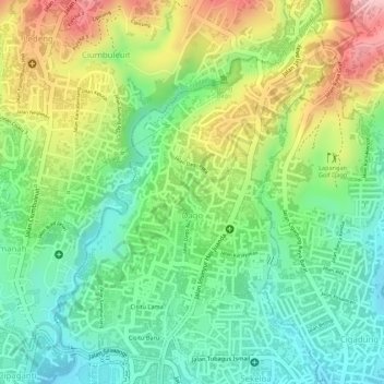
Name: Dago topographic map, elevation, terrain.

Location: Dago, Coblong, Bandung City, West Java, Indonesia (-6.88523 107.60621 -6.86159 107.62618)

Average elevation: 825 m

Minimum elevation: 747 m

Maximum elevation: 938 m

Other topographic maps

Click on a map to view its topography, its elevation and its terrain.

Tegallega Park

Indonesia > West Java > Bandung City > Ciateul

Average elevation: 695 m

Taman Gesit

Indonesia > West Java > Bandung City > Lebak Gede

Average elevation: 746 m

Taman Cibeunying

Indonesia > West Java > Bandung City > Cihapit

Average elevation: 717 m

Taman Pramuka

Indonesia > West Java > Bandung City > Cihapit

Average elevation: 707 m

Gear up for your next adventure:

🍱Food Containers - Reusable containers for outdoor meals
🧥Breathable Waterproof Jackets - Essential rain protection for the unpredictable British climate
🧘Folding Sit Mats - Dry and warm seat for map-reading breaks on damp ground
🥼Base Layers - Thermal base layers for temperature regulation
🔋Solar Power Banks - Keep your GPS and phone charged during multi-day expeditions

As an Amazon Associate, this site earns from qualifying purchases at no extra cost to you.