
Town of Sand Lake topographic map
Interactive map
Click on the map to display elevation.
About this map
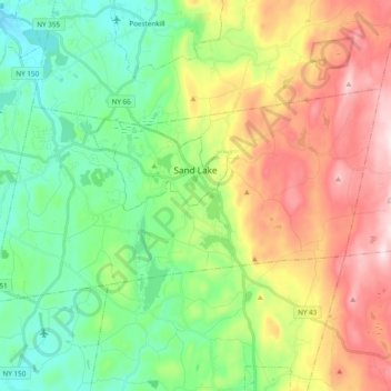
Name: Town of Sand Lake topographic map, elevation, terrain.
Average elevation: 288 m
Minimum elevation: 105 m
Maximum elevation: 593 m
Other topographic maps
Click on a map to view its topography, its elevation and its terrain.
City of Troy
United States > New York > Rensselaer County
City of Troy, Rensselaer County, New York, United States
Average elevation: 81 m
Town of Brunswick
United States > New York > Rensselaer County
Town of Brunswick, Rensselaer County, New York, United States
Average elevation: 238 m
Grafton
United States > New York > Rensselaer County > Grafton
Grafton, Town of Grafton, Rensselaer County, New York, 12082, United States
Average elevation: 454 m
Village of Hoosick Falls
United States > New York > Rensselaer County > Town of Hoosick
Village of Hoosick Falls, Town of Hoosick, Rensselaer County, New York, 12090, United States
Average elevation: 166 m