
Manati topographic map
Interactive map
Click on the map to display elevation.
About this map
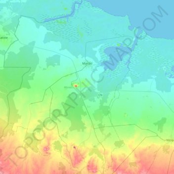
Name: Manati topographic map, elevation, terrain.
Location: Manati, Las Tunas, Cuba (21.06299 -77.14164 21.45753 -76.80120)
Average elevation: 26 m
Minimum elevation: -1 m
Maximum elevation: 115 m
Other topographic maps
Click on a map to view its topography, its elevation and its terrain.
La Division
Cuba > Las Tunas > La Division
La Division, Puerto Padre, Las Tunas, Cuba
Average elevation: 55 m