Geolocate

Decatur topographic map

Click on the map to display elevation.

About this map

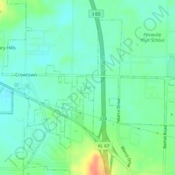
Name: Decatur topographic map, elevation, terrain.

Location: Decatur, Morgan County, Alabama, USA (34.54241 -86.90956 34.54264 -86.90855)

Average elevation: 181 m

Minimum elevation: 167 m

Maximum elevation: 214 m

Gear up for your next adventure:

🧺Mesh Stuff Sacks - Breathable storage for wet gear or camp organization
🧤Thermal Touchscreen Gloves - Stay warm while operating your GPS or smartphone camera
🧥Softshell Jackets - Breathable jackets for active outdoor use
📷Camera Straps - Secure straps for carrying cameras while walking
👖Hiking Trousers - Durable trousers designed for rough terrain

As an Amazon Associate, this site earns from qualifying purchases at no extra cost to you.