
Mankachar topographic map
Interactive map
Click on the map to display elevation.
About this map
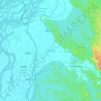
Name: Mankachar topographic map, elevation, terrain.
Location: Mankachar, South Salmara-Mankachar, Assam, India (25.46652 89.82716 25.79180 90.01935)
Average elevation: 53 m
Minimum elevation: 14 m
Maximum elevation: 599 m
Other topographic maps
Click on a map to view its topography, its elevation and its terrain.
Kaziranga National Park and Tiger Reserve
Kaziranga National Park and Tiger Reserve, Bokakhat, Golaghat District, Assam, India
Average elevation: 202 m
North Lakhimpur
North Lakhimpur, Lakhimpur, Assam, India
Average elevation: 96 m
Numaligarh
India > Assam > Bokakhat > Numaligarh
Numaligarh, Bokakhat, Golaghat, Assam, 785615, India
Average elevation: 87 m
Mahatma Gandhi Park
Mahatma Gandhi Park, Chowk Bazar, Atila Gaon, Jorhat, Assam, India
Average elevation: 92 m