
Bazhong topographic map
Interactive map
Click on the map to display elevation.
About this map
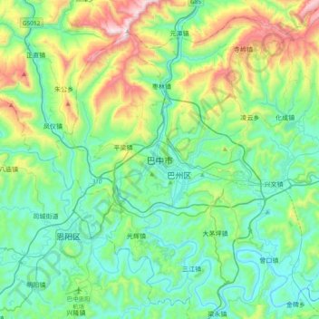
Name: Bazhong topographic map, elevation, terrain.
Average elevation: 574 m
Minimum elevation: 301 m
Maximum elevation: 1,440 m
Bazhong is located at the southern end of the Daba Mountains, and borders Shaanxi province to the north, Dazhou to the east, Nanchong to the south, and Guangyuan to the west. Its area is 12,301 square kilometres (4,749 sq mi), which is mountainous with elevations up to 208.3 to 2,507 metres (683 to 8,225 ft) above sea level.