Geolocate

Barcelonnette topographic map

Click on the map to display elevation.

Barcelonnette

Barcelonnette is situated in the wide and fertile Ubaye Valley, of which it is the largest town. It lies at an elevation of 1132 m (3717 ft) on the right bank of the Ubaye River, and is surrounded by mountains which reach peaks of over 3000 m; the tallest of these is the Needle of Chambeyron at 3412 m. Barcelonnette is situated 210 km from Turin, 91 km from Nice and 68 km from Gap.

About this map

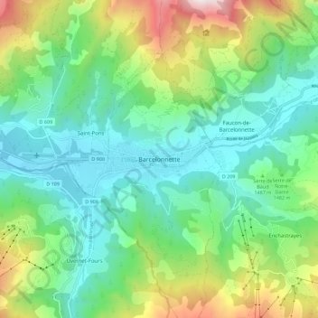
Name: Barcelonnette topographic map, elevation, terrain.

Location: Barcelonnette, Alpes-de-Haute-Provence, Provence-Alpes-Côte d'Azur, Metropolitan France, 04400, France (44.34620 6.61136 44.42620 6.69136)

Average elevation: 1,494 m

Minimum elevation: 1,103 m

Maximum elevation: 2,479 m

Gear up for your next adventure:

👖Packable Overtrousers - Quick-deploy rain protection for legs in sudden storms
🔥Emergency Fire Starters - Reliable ignition tools for survival situations in damp conditions
Altimeter Watches - Watches measuring altitude for mountain activities
🧼Biodegradable Soap - Leave-no-trace hygiene for multi-day mountain treks
🧭Professional Hiking Compasses - High-precision liquid-filled compasses for map reading and orientation

As an Amazon Associate, this site earns from qualifying purchases at no extra cost to you.