
Make a donation
Gear up for your next adventure:
As an Amazon Associate, this site earns from qualifying purchases at no extra cost to you.
Alpine topographic map
Click on the map to display elevation.
Make a donation
Gear up for your next adventure:
As an Amazon Associate, this site earns from qualifying purchases at no extra cost to you.
Alpine
Alpine (/ˈælpaɪn/ AL-pyne) is a city in and the county seat of Brewster County, Texas, United States. The population was 5,905 at the 2010 census. The town has an elevation of 4,462 feet (1,360 m), and the surrounding mountain peaks are over 1 mile (1.6 km) above sea level. A university, hospital, library, and retail make Alpine the center of the sprawling 12,000 square miles (3,108,000 ha) but wide open Big Bend area (combined population 12,500) including Brewster, Presidio, and Jeff Davis counties.
Make a donation
Gear up for your next adventure:
As an Amazon Associate, this site earns from qualifying purchases at no extra cost to you.
About this map
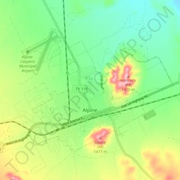
Name: Alpine topographic map, elevation, terrain.
Location: Alpine, Brewster County, Texas, United States (30.34404 -103.70590 30.39172 -103.62556)
Average elevation: 1,373 m
Minimum elevation: 1,305 m
Maximum elevation: 1,493 m
Make a donation
Gear up for your next adventure:
As an Amazon Associate, this site earns from qualifying purchases at no extra cost to you.
Other topographic maps
Click on a map to view its topography, its elevation and its terrain.
Big Bend National Park
United States > Texas > Brewster County
Big Bend National Park is an American national park located in West Texas, bordering Mexico. The park has national significance as the largest protected area of Chihuahuan Desert topography and ecology in the United States, and was named after a large bend in the Rio Grande/Río Bravo. The park protects more…
Average elevation: 934 m
Emory Peak
United States > Texas > Brewster County
The peak can be reached by a moderate hike on a well-marked path across steep rocky terrain with an elevation gain of approximately 2,500 feet (760 m). The Emory Peak Trail is about 1.5 miles (2.4 km) long. The trail is reached by climbing the Pinnacles Trail 3.5 miles (5.6 km) from the Chisos Basin trailhead.…
Average elevation: 2,061 m
Make a donation
Gear up for your next adventure:
As an Amazon Associate, this site earns from qualifying purchases at no extra cost to you.