
Cham topographic map
Interactive map
Click on the map to display elevation.
About this map
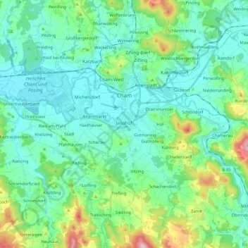
Name: Cham topographic map, elevation, terrain.
Location: Cham, Landkreis Cham, Bayern, 93413, Deutschland (49.13569 12.55751 49.26879 12.75501)
Average elevation: 420 m
Minimum elevation: 357 m
Maximum elevation: 662 m
Der Ort Cham wurde im Jahr 976 als Civitas Camma erstmals als Stadt erwähnt. Sie lag damals auf dem Höhenzug bei dem Dorf Altenstadt und war der Reichsburg Camma, die den Handelsweg nach Böhmen sicherte, untertänig.