
English Garden topographic map
Interactive map
Click on the map to display elevation.
About this map
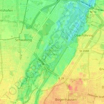
Name: English Garden topographic map, elevation, terrain.
Location: English Garden, Schwabing-Freimann, Munich, Bavaria, Germany (48.14323 11.58374 48.18658 11.62871)
Average elevation: 512 m
Minimum elevation: 488 m
Maximum elevation: 539 m
Other topographic maps
Click on a map to view its topography, its elevation and its terrain.
Altstadt-Lehel
Altstadt-Lehel, Munich, Bavaria, Germany
Average elevation: 521 m
Neuperlach
Neuperlach, Ramersdorf-Perlach, Munich, Bavaria, 81735, Germany
Average elevation: 541 m