
Make a donation
Gear up for your next adventure:
As an Amazon Associate, this site earns from qualifying purchases at no extra cost to you.
Hornberg topographic map
Click on the map to display elevation.
Make a donation
Gear up for your next adventure:
As an Amazon Associate, this site earns from qualifying purchases at no extra cost to you.
About this map
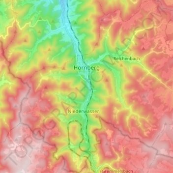
Name: Hornberg topographic map, elevation, terrain.
Location: Hornberg, Ortenaukreis, Baden-Württemberg, 78132, Germany (48.15823 8.17916 48.24770 8.31301)
Average elevation: 691 m
Minimum elevation: 294 m
Maximum elevation: 1,007 m
Make a donation
Gear up for your next adventure:
As an Amazon Associate, this site earns from qualifying purchases at no extra cost to you.
Other topographic maps
Click on a map to view its topography, its elevation and its terrain.
Obergieß
Germany > Baden-Württemberg > Ortenaukreis > Hornberg > Niederwasser
Average elevation: 717 m
Mattenhof
Germany > Baden-Württemberg > Ortenaukreis > Gutach (Schwarzwaldbahn)
Average elevation: 402 m
Make a donation
Gear up for your next adventure:
As an Amazon Associate, this site earns from qualifying purchases at no extra cost to you.
Make a donation
Gear up for your next adventure:
As an Amazon Associate, this site earns from qualifying purchases at no extra cost to you.