
Make a donation
Gear up for your next adventure:
As an Amazon Associate, this site earns from qualifying purchases at no extra cost to you.
Volcán Calbuco topographic map
Click on the map to display elevation.
Make a donation
Gear up for your next adventure:
As an Amazon Associate, this site earns from qualifying purchases at no extra cost to you.
Volcán Calbuco
Calbuco (/kɑːlˈbuːkoʊ/ kahl-BOO-koh; Spanish: Volcán Calbuco, pronounced ) is a stratovolcano in southern Chile, located southeast of Llanquihue Lake and northwest of Chapo Lake, in the Los Lagos Region, and close to the cities of Puerto Varas and Puerto Montt. With an elevation of 2,015 meters above sea level, the volcano and the surrounding area are protected within the Llanquihue National Reserve.
Make a donation
Gear up for your next adventure:
As an Amazon Associate, this site earns from qualifying purchases at no extra cost to you.
About this map
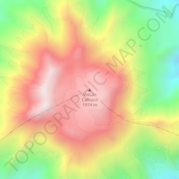
Name: Volcán Calbuco topographic map, elevation, terrain.
Average elevation: 1,581 m
Minimum elevation: 1,111 m
Maximum elevation: 1,990 m
Make a donation
Gear up for your next adventure:
As an Amazon Associate, this site earns from qualifying purchases at no extra cost to you.