
Kitsjanovo topographic map
Interactive map
Click on the map to display elevation.
About this map
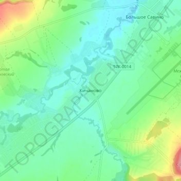
Name: Kitsjanovo topographic map, elevation, terrain.
Average elevation: 117 m
Minimum elevation: 93 m
Maximum elevation: 181 m
Other topographic maps
Click on a map to view its topography, its elevation and its terrain.
Сыра
Russia > Perm Krai > Permsky District > Мостовая
Сыра, Мостовая, Dvurechenskoe Rural Settlement, Permsky District, Perm Krai, Volga Federal District, 614536, Russia
Average elevation: 184 m