Geolocate

Cerro topographic map

Click on the map to display elevation.

About this map

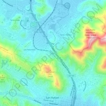
Name: Cerro topographic map, elevation, terrain.

Location: Cerro, San Rafael, Marin County, California, 94903, United States (37.97159 -122.55137 38.01159 -122.51137)

Average elevation: 58 m

Minimum elevation: -2 m

Maximum elevation: 269 m

Other topographic maps

Click on a map to view its topography, its elevation and its terrain.

Gear up for your next adventure:

🧷Tenacious Repair Tape - Instant fix for torn tents, jackets, or dry bags
🧺Ultralight Dry Bags - Organize and waterproof your gear inside your rucksack
🧼Camping Hygiene Kits - Compact hygiene essentials for outdoor stays
🎿Telescopic Trekking Poles - Reduces knee strain on steep topographic descents
🔋Solar Chargers - Eco-friendly charging solutions for outdoor use

As an Amazon Associate, this site earns from qualifying purchases at no extra cost to you.