
Thank you for supporting this site ❤️
Make a donation
Make a donation
Gear up for your next adventure:
As an Amazon Associate, this site earns from qualifying purchases at no extra cost to you.
Chancaybaños topographic map
Click on the map to display elevation.
Thank you for supporting this site ❤️
Make a donation
Make a donation
Gear up for your next adventure:
As an Amazon Associate, this site earns from qualifying purchases at no extra cost to you.
About this map
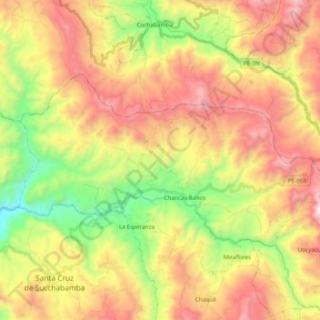
Name: Chancaybaños topographic map, elevation, terrain.
Location: Chancaybaños, Provincia de Santa Cruz, Cajamarca, Perú (-6.60449 -78.96568 -6.50346 -78.77665)
Average elevation: 2,054 m
Minimum elevation: 1,289 m
Maximum elevation: 2,873 m
Thank you for supporting this site ❤️
Make a donation
Make a donation
Gear up for your next adventure:
As an Amazon Associate, this site earns from qualifying purchases at no extra cost to you.
Other topographic maps
Click on a map to view its topography, its elevation and its terrain.