
Montmeyre topographic map
Interactive map
Click on the map to display elevation.
About this map
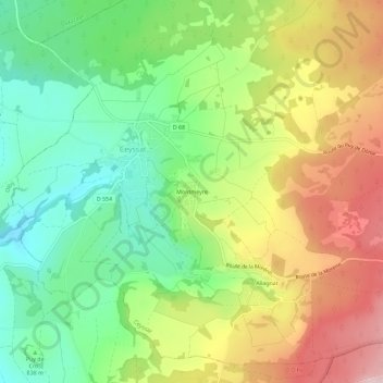
Name: Montmeyre topographic map, elevation, terrain.
Average elevation: 865 m
Minimum elevation: 751 m
Maximum elevation: 1,016 m
Other topographic maps
Click on a map to view its topography, its elevation and its terrain.
Puy de Côme
France > Auvergne-Rhône-Alpes > Puy-de-Dôme > Ceyssat
Puy de Côme, Ceyssat, Issoire, Puy-de-Dôme, Auvergne-Rhône-Alpes, France métropolitaine, 63210, France
Average elevation: 1,004 m
Allagnat
France > Auvergne-Rhône-Alpes > Puy-de-Dôme > Ceyssat
Allagnat, Ceyssat, Issoire, Puy-de-Dôme, Auvergne-Rhône-Alpes, France métropolitaine, 63210, France
Average elevation: 916 m
Le Grand Suchet
France > Auvergne-Rhône-Alpes > Puy-de-Dôme > Ceyssat
Le Grand Suchet, Ceyssat, Issoire, Puy-de-Dôme, Auvergne-Rhône-Alpes, France métropolitaine, 63210, France
Average elevation: 1,079 m
Château d'Allagnat
France > Auvergne-Rhône-Alpes > Puy-de-Dôme > Ceyssat > Allagnat
Château d'Allagnat, Impasse de l'Église, Allagnat, Ceyssat, Issoire, Puy-de-Dôme, Auvergne-Rhône-Alpes, France métropolitaine, 63210, France
Average elevation: 925 m