
Loerbeek topographic map
Interactive map
Click on the map to display elevation.
About this map
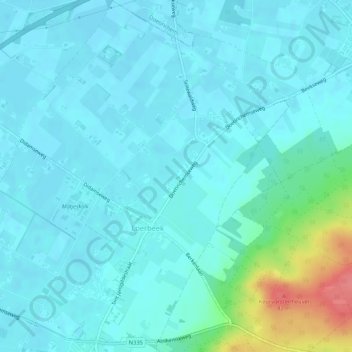
Name: Loerbeek topographic map, elevation, terrain.
Location: Loerbeek, Montferland, Gelderland, Nederland (51.90808 6.17901 51.94088 6.22950)
Average elevation: 25 m
Minimum elevation: 13 m
Maximum elevation: 86 m
Other topographic maps
Click on a map to view its topography, its elevation and its terrain.
Kilder
Nederland > Gelderland > Montferland
Kilder, Montferland, Gelderland, Nederland
Average elevation: 27 m
Hettenheuvel
Nederland > Gelderland > Montferland
Hettenheuvel, Montferland, Gelderland, Nederland, 7035DH, Nederland
Average elevation: 42 m
Azewijn
Nederland > Gelderland > Montferland
Azewijn, Montferland, Gelderland, Nederland
Average elevation: 15 m
Kasteel Huis Bergh
Nederland > Gelderland > Montferland
Kasteel Huis Bergh, 8, Hof van Bergh, 's-Heerenberg, Montferland, Gelderland, Nederland, 7040AD, Nederland
Average elevation: 21 m
Hulzenberg
Nederland > Gelderland > Montferland
Hulzenberg, Montferland, Gelderland, Nederland, 7039CV, Nederland
Average elevation: 34 m