
Make a donation
Gear up for your next adventure:
As an Amazon Associate, this site earns from qualifying purchases at no extra cost to you.
Al-Bab topographic map
Click on the map to display elevation.
Make a donation
Gear up for your next adventure:
As an Amazon Associate, this site earns from qualifying purchases at no extra cost to you.
Al-Bab
Al-Bab (Arabic: الْبَاب / ALA-LC: al-Bāb) is a city, de jure administratively belonging to the Aleppo Governorate of the Syrian Arab Republic. As of December 2016, the city is under the control of pro-Turkish militias, as part of the Turkish occupation of northern Syria. Al-Bab is located 40 kilometres (25 mi) northeast of Aleppo, 30 kilometres (19 mi) south of the Turkish border, and has an area of 30 square kilometres (12 square miles). Al-Bab has an altitude of 471 metres (1,545 feet). According to the Central Bureau of Statistics (CBS), it had a population of 63,069 in 2004. The population has surged to about 100,000 during the Syrian Civil War. Prior to the Syrian Civil War, al-Bab's inhabitants were composed of a Sunni Arab majority, and a Kurdish minority outside the city center.
Make a donation
Gear up for your next adventure:
As an Amazon Associate, this site earns from qualifying purchases at no extra cost to you.
About this map
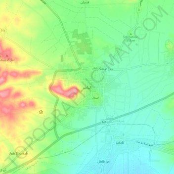
Name: Al-Bab topographic map, elevation, terrain.
Average elevation: 471 m
Minimum elevation: 363 m
Maximum elevation: 561 m
Make a donation
Gear up for your next adventure:
As an Amazon Associate, this site earns from qualifying purchases at no extra cost to you.
Other topographic maps
Click on a map to view its topography, its elevation and its terrain.
Make a donation
Gear up for your next adventure:
As an Amazon Associate, this site earns from qualifying purchases at no extra cost to you.
Make a donation
Gear up for your next adventure:
As an Amazon Associate, this site earns from qualifying purchases at no extra cost to you.