
Jilemnice topographic map
Interactive map
Click on the map to display elevation.
About this map
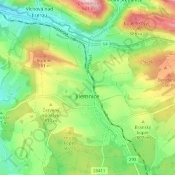
Name: Jilemnice topographic map, elevation, terrain.
Location: Jilemnice, okres Semily, Liberecký kraj, Northeast, Czechia (50.58950 15.48259 50.63301 15.54503)
Average elevation: 482 m
Minimum elevation: 392 m
Maximum elevation: 623 m
Other topographic maps
Click on a map to view its topography, its elevation and its terrain.