
Make a donation
Gear up for your next adventure:
As an Amazon Associate, this site earns from qualifying purchases at no extra cost to you.
Randazzo topographic map
Click on the map to display elevation.
Make a donation
Gear up for your next adventure:
As an Amazon Associate, this site earns from qualifying purchases at no extra cost to you.
Randazzo
The geographical position of Randazzo also contributes to its climate. The town experiences a Mediterranean climate, characterized by hot, dry summers and mild, rainy winters. However, due to its proximity to Mount Etna, microclimates can be observed, with variations in temperature and precipitation depending on altitude and local conditions.
Make a donation
Gear up for your next adventure:
As an Amazon Associate, this site earns from qualifying purchases at no extra cost to you.
About this map
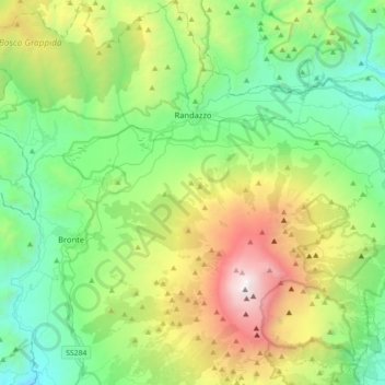
Name: Randazzo topographic map, elevation, terrain.
Location: Randazzo, Catania, Sicily, 95036, Italy (37.68089 14.70573 37.96111 15.02400)
Average elevation: 1,143 m
Minimum elevation: 275 m
Maximum elevation: 3,313 m
Make a donation
Gear up for your next adventure:
As an Amazon Associate, this site earns from qualifying purchases at no extra cost to you.
Other topographic maps
Click on a map to view its topography, its elevation and its terrain.
Mount Etna
During the first 1500 years AD, many eruptions went unrecorded (or records have been lost); among the more significant are: (1) an eruption in about 1030 AD near Monte Ilice on the lower southeast flank, which produced a lava flow that travelled about 10 km, reaching the sea north of Acireale; the villages of…
Average elevation: 1,157 m
Etna
Italy > Sicily > Catania > Zafferana Etnea
Eruptions of Etna follow multiple patterns. Most occur at the summit, where there are five distinct craters: the Northeast Crater, the Voragine, the Bocca Nuova, and two at the Southeast Crater Complex. Other eruptions occur on the flanks, which have more than 300 vents ranging in size from small holes in the…
Average elevation: 2,976 m
Make a donation
Gear up for your next adventure:
As an Amazon Associate, this site earns from qualifying purchases at no extra cost to you.
Etna
Italy > Sicily > Catania > Zafferana Etnea
Eruptions of Etna follow multiple patterns. Most occur at the summit, where there are five distinct craters – the Northeast Crater, the Voragine, the Bocca Nuova, and two at the Southeast Crater Complex. Other eruptions occur on the flanks, which have more than 300 vents ranging in size from small holes in…
Average elevation: 2,976 m