Geolocate

Tarbert topographic map

Click on the map to display elevation.

About this map

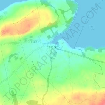
Name: Tarbert topographic map, elevation, terrain.

Location: Tarbert, County Kerry, Munster, V31 WD66, Ireland (52.56552 -9.39388 52.57671 -9.35638)

Average elevation: 22 m

Minimum elevation: 0 m

Maximum elevation: 62 m

Other topographic maps

Click on a map to view its topography, its elevation and its terrain.

Glencloosagh Bay

Ireland > County Kerry

Average elevation: 12 m

Knocknagashel

Ireland > County Kerry

Average elevation: 154 m

Brandon Mountain

Ireland > County Kerry

Average elevation: 572 m

Glencar

Ireland > County Kerry

Average elevation: 114 m

Kenmare

Ireland > County Kerry > Kenmare

Average elevation: 87 m

Beaufort

Ireland > County Kerry

Average elevation: 41 m

Stradbally Mountain

Ireland > County Kerry

Average elevation: 487 m

Castlegregory

Ireland > County Kerry

Average elevation: 17 m

Murreagh

Ireland > County Kerry

Average elevation: 37 m

Ballyduff

Ireland > County Kerry > Ballyduff

Average elevation: 29 m

Brick

Ireland > County Kerry

Average elevation: 4 m

Kilmorna

Ireland > County Kerry

Average elevation: 65 m

Scartaglin

Ireland > County Kerry > Scartaglin

Average elevation: 135 m

Rathmore

Ireland > County Kerry > Rathmore

Average elevation: 154 m

Killorglin

Ireland > County Kerry > Killorglin

Average elevation: 24 m

Gear up for your next adventure:

📚UK Hiking Guidebooks - Detailed route descriptions for the Lake District, Peaks, and Highlands
🧼Biodegradable Soap - Leave-no-trace hygiene for multi-day mountain treks
📻Hand-Crank Emergency Radios - Stay updated on weather warnings in remote areas
📦Dry Bags - Waterproof bags to protect gear from rain
📷Camera Straps - Secure straps for carrying cameras while walking

As an Amazon Associate, this site earns from qualifying purchases at no extra cost to you.