
Make a donation
Gear up for your next adventure:
As an Amazon Associate, this site earns from qualifying purchases at no extra cost to you.
Churwalden topographic map
Click on the map to display elevation.
Make a donation
Gear up for your next adventure:
As an Amazon Associate, this site earns from qualifying purchases at no extra cost to you.
About this map
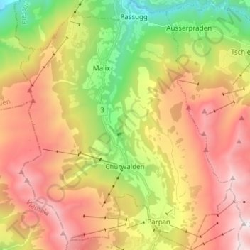
Name: Churwalden topographic map, elevation, terrain.
Location: Churwalden, Plessur, Grisons, Switzerland (46.75015 9.49111 46.83505 9.59647)
Average elevation: 1,688 m
Minimum elevation: 621 m
Maximum elevation: 2,792 m
Make a donation
Gear up for your next adventure:
As an Amazon Associate, this site earns from qualifying purchases at no extra cost to you.
Other topographic maps
Click on a map to view its topography, its elevation and its terrain.
Haldenstein
Switzerland > Grisons > Plessur > Chur
Before 2017, the municipality was located in the Fünf Dörfer sub-district of the Landquart district, after 2017 it was part of the Plessur Region. It is located north of Chur and on the left bank of the Rhine River. It consists of the haufendorf (an irregular, unplanned and quite closely packed village,…
Average elevation: 826 m
Make a donation
Gear up for your next adventure:
As an Amazon Associate, this site earns from qualifying purchases at no extra cost to you.