

Make a donation
Gear up for your next adventure:
As an Amazon Associate, this site earns from qualifying purchases at no extra cost to you.
River Severn topographic map
Click on the map to display elevation.
Make a donation
Gear up for your next adventure:
As an Amazon Associate, this site earns from qualifying purchases at no extra cost to you.
River Severn
The River Severn (Welsh: Afon Hafren, pronounced [ˈavɔn ˈhavrɛn]), at 220 miles (354 km) long, is the longest river in Great Britain. It is also the river with the most voluminous flow of water by far in all of England and Wales, with an average flow rate of 107 m3/s (3,800 cu ft/s) at Apperley, Gloucestershire. It rises in the Cambrian Mountains in mid Wales, at an altitude of 2,001 feet (610 m), on the Plynlimon massif, which lies close to the Ceredigion/Powys border near Llanidloes. The river then flows through Shropshire, Worcestershire and Gloucestershire. The county towns of Shrewsbury, Worcester and Gloucester lie on its course.
Make a donation
Gear up for your next adventure:
As an Amazon Associate, this site earns from qualifying purchases at no extra cost to you.
About this map
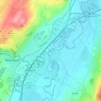
Name: River Severn topographic map, elevation, terrain.
Average elevation: 92 m
Minimum elevation: 65 m
Maximum elevation: 178 m
Powys trails, hiking, mountain biking, running and outdoor activities
Make a donation
Gear up for your next adventure:
As an Amazon Associate, this site earns from qualifying purchases at no extra cost to you.