Geolocate

Morija topographic map

Interactive map

Click on the map to display elevation.

About this map

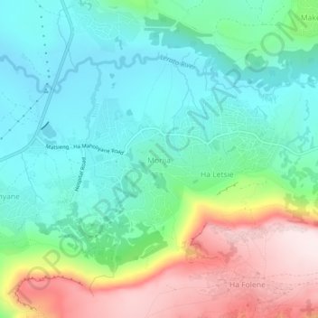
Name: Morija topographic map, elevation, terrain.

Location: Morija, Maseru District, Lesotho (-29.64501 27.49426 -29.60501 27.53426)

Average elevation: 1,767 m

Minimum elevation: 1,610 m

Maximum elevation: 2,108 m

Other topographic maps

Click on a map to view its topography, its elevation and its terrain.

Manong

Lesotho > Maseru District

Manong, Maseru District, Lesotho

Average elevation: 2,688 m

PTC

Lesotho > Maseru District > Maseru

PTC, Maseru, Maseru District, 100, Lesotho

Average elevation: 1,649 m

Maqalika Dam

Lesotho > Maseru District > Maseru

Maqalika Dam, Maseru, Maseru District, 100, Lesotho

Average elevation: 1,540 m

Maseru

Lesotho > Maseru District

Maseru, Maseru District, 100, Lesotho

Average elevation: 1,606 m