
Umfolozi River topographic map
Interactive map
Click on the map to display elevation.
About this map
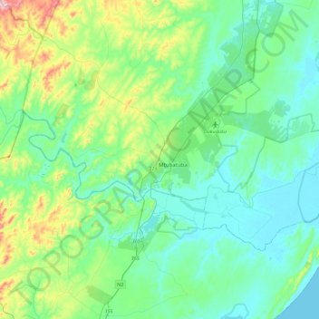
Name: Umfolozi River topographic map, elevation, terrain.
Average elevation: 75 m
Minimum elevation: 0 m
Maximum elevation: 367 m
Other topographic maps
Click on a map to view its topography, its elevation and its terrain.
Richards Bay
South Africa > KwaZulu-Natal > King Cetswayo District Municipality
Richards Bay, uMhlathuze Local Municipality, King Cetswayo District Municipality, KwaZulu-Natal, 3900, South Africa
Average elevation: 31 m
Mpangeni
South Africa > KwaZulu-Natal > King Cetswayo District Municipality > uMhlathuze Local Municipality
Mpangeni, Richem, uMhlathuze Ward 9, uMhlathuze Local Municipality, King Cetswayo District Municipality, KwaZulu-Natal, 3381, South Africa
Average elevation: 66 m
Gingindlovu
South Africa > KwaZulu-Natal > King Cetswayo District Municipality > uMlalazi Local Municipality
Gingindlovu, uMlalazi Local Municipality, King Cetswayo District Municipality, KwaZulu-Natal, South Africa
Average elevation: 66 m
uThukela
South Africa > KwaZulu-Natal > King Cetswayo District Municipality > uMlalazi Local Municipality
uThukela, uMlalazi Local Municipality, King Cetswayo District Municipality, KwaZulu-Natal, South Africa
Average elevation: 238 m
Richard's Bay Harbour Mangroves
South Africa > KwaZulu-Natal > King Cetswayo District Municipality > Richards Bay
Richard's Bay Harbour Mangroves, uMhlathuze Ward 2, Richards Bay, uMhlathuze Local Municipality, King Cetswayo District Municipality, KwaZulu-Natal, South Africa
Average elevation: 3 m
Sikhalasenkosi
South Africa > KwaZulu-Natal > King Cetswayo District Municipality > uMhlathuze Local Municipality
Sikhalasenkosi, uMhlathuze Local Municipality, King Cetswayo District Municipality, KwaZulu-Natal, South Africa
Average elevation: 32 m
Eshowe
South Africa > KwaZulu-Natal > King Cetswayo District Municipality > uMlalazi Local Municipality
Eshowe, uMlalazi Local Municipality, King Cetswayo District Municipality, KwaZulu-Natal, South Africa
Average elevation: 457 m
Mthonjaneni Local Municipality
South Africa > KwaZulu-Natal > King Cetswayo District Municipality
Mthonjaneni Local Municipality, King Cetswayo District Municipality, KwaZulu-Natal, 3835, South Africa
Average elevation: 724 m
Empangeni
South Africa > KwaZulu-Natal > King Cetswayo District Municipality > uMhlathuze Local Municipality
Empangeni, uMhlathuze Local Municipality, King Cetswayo District Municipality, KwaZulu-Natal, 3381, South Africa
Average elevation: 89 m
Nkandla
South Africa > KwaZulu-Natal > King Cetswayo District Municipality > Nkandla Local Municipality
Nkandla, Nkandla Local Municipality, King Cetswayo District Municipality, KwaZulu-Natal, South Africa
Average elevation: 1,040 m
uMngwenya
South Africa > KwaZulu-Natal > King Cetswayo District Municipality > uMlalazi Local Municipality
uMngwenya, uMlalazi Local Municipality, King Cetswayo District Municipality, KwaZulu-Natal, South Africa
Average elevation: 438 m
Ntshongweni
South Africa > KwaZulu-Natal > King Cetswayo District Municipality > Nkandla Local Municipality
Ntshongweni, Nkandla Local Municipality, King Cetswayo District Municipality, KwaZulu-Natal, South Africa
Average elevation: 682 m
Mtunzini
South Africa > KwaZulu-Natal > King Cetswayo District Municipality > uMlalazi Local Municipality > Mtunzini
Mtunzini, uMlalazi Local Municipality, King Cetswayo District Municipality, KwaZulu-Natal, 3867, South Africa
Average elevation: 31 m
uMlalazi Local Municipality
South Africa > KwaZulu-Natal > King Cetswayo District Municipality
uMlalazi Local Municipality, King Cetswayo District Municipality, KwaZulu-Natal, South Africa
Average elevation: 335 m
uMfolozi Local Municipality
South Africa > KwaZulu-Natal > King Cetswayo District Municipality
uMfolozi Local Municipality, King Cetswayo District Municipality, KwaZulu-Natal, 3915, South Africa
Average elevation: 61 m
uMhlathuze Local Municipality
South Africa > KwaZulu-Natal > King Cetswayo District Municipality
uMhlathuze Local Municipality, King Cetswayo District Municipality, KwaZulu-Natal, South Africa
Average elevation: 51 m