Geolocate

Moscow topographic map

Click on the map to display elevation.

About this map

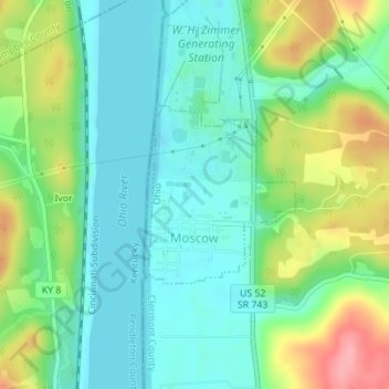
Name: Moscow topographic map, elevation, terrain.

Location: Moscow, Washington Township, Clermont County, Ohio, United States (38.85433 -84.23363 38.86665 -84.21952)

Average elevation: 177 m

Minimum elevation: 141 m

Maximum elevation: 255 m

Other topographic maps

Click on a map to view its topography, its elevation and its terrain.

The Highlands

United States > Ohio > Clermont County

Average elevation: 218 m

Hills

United States > Ohio > Clermont County

Average elevation: 243 m

Perintown

United States > Ohio > Clermont County

Average elevation: 199 m

Cedron

United States > Ohio > Clermont County

Average elevation: 228 m

Saltair

United States > Ohio > Clermont County

Average elevation: 268 m

Amelia

United States > Ohio > Clermont County

Average elevation: 265 m

The Highlands

United States > Ohio > Clermont County

Average elevation: 218 m

The Highlands

United States > Ohio > Clermont County

Average elevation: 218 m

Laurel

United States > Ohio > Clermont County

Average elevation: 252 m

Tobasco

United States > Ohio > Clermont County > Tobasco

Average elevation: 269 m

Gear up for your next adventure:

🛑Emergency Bivvy Bags - Heat-reflective survival bags for unexpected nights out
🎒Hiking Backpacks - Comfortable backpacks for day hikes and multi-day treks
🥤Hiking Water Bottles - Reusable bottles for hydration on the trail
🧴Tick Removal Tools - Small, essential health tool for UK woodland and moorland
🔋Lithium AA Batteries - Long-lasting power that performs well in cold mountain weather

As an Amazon Associate, this site earns from qualifying purchases at no extra cost to you.