
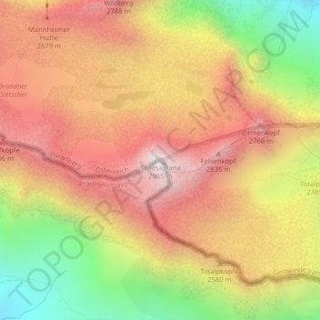
Schesaplana topographic map
Interactive map
Click on the map to display elevation.
About this map
Name: Schesaplana topographic map, elevation, terrain.
Average elevation: 2,446 m
Minimum elevation: 1,791 m
Maximum elevation: 2,945 m
Other topographic maps
Click on a map to view its topography, its elevation and its terrain.
Schesaplanahütte - SAC
Zwitserland > Graubünden > Prättigau/Davos > Seewis im Prättigau
Schesaplanahütte - SAC, Golrosaweg, Seewis im Prättigau, Prättigau/Davos, Graubünden, 7228, Zwitserland
Average elevation: 1,987 m