
Klyuchi topographic map
Interactive map
Click on the map to display elevation.
About this map
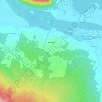
Name: Klyuchi topographic map, elevation, terrain.
Average elevation: 57 m
Minimum elevation: 8 m
Maximum elevation: 258 m
Other topographic maps
Click on a map to view its topography, its elevation and its terrain.
Klyuchevskaya Sopka
Russia > Kamchatka Krai > Ust-Kamchatsky District
Klyuchevskaya Sopka (Russian: Ключевская сопка; also known as Klyuchevskoi, Russian: Ключевской) is a stratovolcano, the highest mountain of Siberia and the highest active volcano of Eurasia. Its steep, symmetrical cone towers about 100 kilometres (60 mi) from the Bering Sea. The…
Average elevation: 4,138 m