
Lavail topographic map
Interactive map
Click on the map to display elevation.
About this map
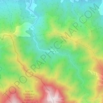
Name: Lavail topographic map, elevation, terrain.
Average elevation: 394 m
Minimum elevation: 74 m
Maximum elevation: 925 m
Other topographic maps
Click on a map to view its topography, its elevation and its terrain.
La Massane
France > Occitanie > Pyrénées-Orientales > Sorède
La Massane, Sorède, Céret, Pyrénées-Orientales, Occitanie, France métropolitaine, 66690, France
Average elevation: 363 m
La Vallée Heureuse
France > Occitanie > Pyrénées-Orientales > Sorède
La Vallée Heureuse, Sorède, Céret, Pyrénées-Orientales, Occitanie, France métropolitaine, 66690, France
Average elevation: 349 m